Sunday, June 28th:
Today we drove 146 miles. The first 60 miles of our drive was through the same dry, rocky, hilly, and treeless countryside to which we had become accustomed. Unfortunately, at least for our car's transmission, much of the drive was uphill until we reached the Manastash Ridge at elevation 2,672 feet, about 1,900 feet above the elevation of our campsite on the Yatama Nation Indian Reservation and around 1,100 feet above the city of Ellensburg located just to the north of the ridge. The view from the Manastash Ridge shown in the above photograph is looking down into the Yakima River Valley and the City of Ellenburg. Off in the distance are Washington State's famous Cascades Mountains where we will cross today.

This topographical map of Washington State shows clearly the type of terrain through which we passed. Our drive began just south of Yakima shown in the lower center of the map along I-82. To the west of us both of which could be seen in the distance as we drove northwest, were the snow capped mountain peaks of Mt. Adams and Mt Rainier the two highest mountains in Washington. Just south of Ellensburg we connected with I-90 which we then followed across the Cascade Mountains to our final destination in the city of Issaquah located about 15 miles east of Seattle. Incidentally, for those of you who live in the Boston area, did you know that you can drive all the way out to Seattle, Washington on I-90. No maps needed, Just I-90.

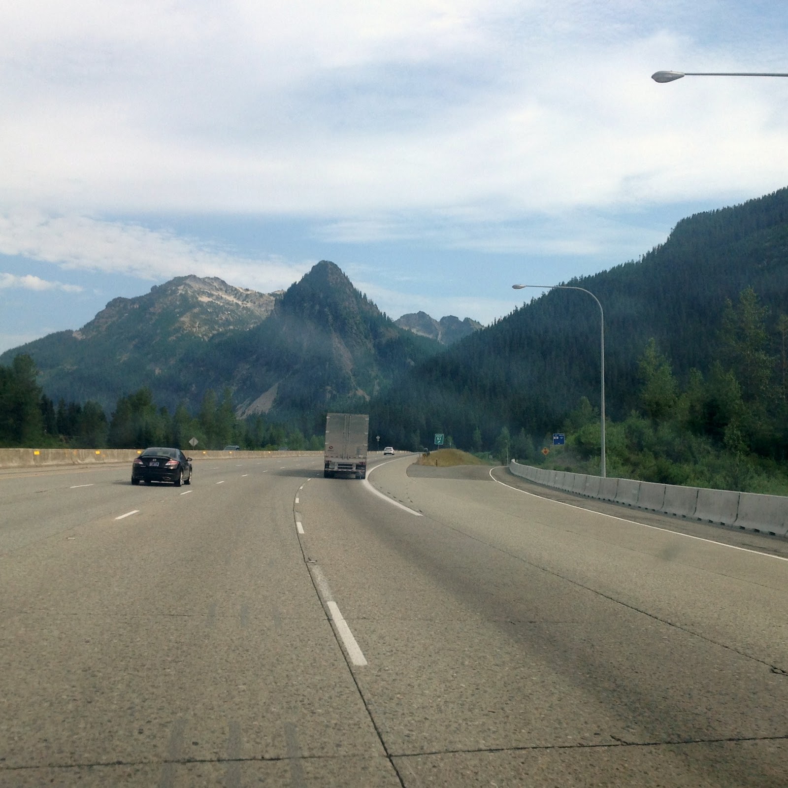
Were in not for the incredible amount of traffic on I-90, the drive through the Cascade Mountains would have been the highlight so far of our entire trip to the West. While we obviously did not take the photograph to the right since it was taken far above our interstate highway, it does show clearly the type of scenery that we encountered during our 60 mile drive across these mountains. According to Wikipedia if it can be believed, an average of 27,087 vehicles (10,000 of which are trucks) pass through these mountains on an average day. Apparently the high volume of traffic may not slow down much in the winter since before the beginning of the uphill climb there were large pull-off areas along the interstate where drivers, particularly truckers, are provided the room to "Chain-Up". No way in the winter for us.

Kathy took this photograph just before we crossed through the Snoqualmie Pass at elevation 3,022 feet. Prior to reaching the pass we had climbed almost 1,500 feet, almost as much as we had climbed only a few hours earlier to reach the Manastask Ridge (oh, our poor transmission). But transmission be damned! This drive through the Cascade Mountains was so spectacularly beautiful. Awe inspiring even. Once we crossed the Snoqualmie Pass it was all downhill, a distance to our campground of around 36 miles. I never once in all that distance had to use the accelerator and only occasionally did I have to apply the breaks. The Interstate at this point was four lanes wide. Let 'em ride. A mad rush to the bottom. Incidentally, the nickname for the State of Washington is the Evergreen State. Our passage through the Cascade Mountains and into the Seattle area showed us why the state bears this name. Pines, firs, and Hemlock trees covered the mountainsides everywhere but on the rocky, snow covered mountaintops.

We have see hundreds of different types of trailers and motorhomes on our trip west but his particular large and rather old Airstream motorhome has to be our best find yet. It was occupied by a young couple with three young kids and from what we could tell they appeared to be having fun.

We arrived at our campground, the Issaquah Village RV Park, around 11 am and despite the still early hour we were both tired, in part because the drive itself can be tiring, but also because we cannot seem to break the habit of getting up early. This morning we were up and about just before 5 am. It was already light outside, it was cool for a change, and besides it was almost 8 am in Florida. We were ready to get on the road again and explore some more of our country. Unfortunately, when we arrived at the Issaquah Village RV Park we discovered that it was a bit of a disappointment. While it was fairly highly rated by "Good Sams," as you can see in the photograph it was very crowded and the spaces allowed for each unit were so small that we could not even put out our awning. Our little trailer was also a little intimidated having to look at such huge thugs on both of its sides. Furthermore Kathy and I were even slightly intimidated enough to kept our blinds closed for the rest of the afternoon and evening. Camping is not always in the great and wide outdoors. We joked that we might have better stayed in a wide open Walmart parking lot. Just kidding! Well, maybe not.

Monday, June 29th:
We made the huge mistake of again getting up early and then heading out to downtown Seattle by 8:30 am, just about the same time as the 660,000 residents of Seattle were all headed for work or play. The traffic on the interstate was bumper to bumper for almost the entire 15 miles into downtown Seattle. We knew immediately that no matter how beautiful we would find the city, the hustle and bustle of the roads and the city crowds would probably dampen our levels of pleasure. As it turned out, it was hard to enjoy Seattle. The parking was expensive and the downtown driving for this old man was just too much.

One thing that we had to do, if nothing else, was to visit Seattle's famous Space/Needle which was located downtown in an area known as Seattle Center. Fortunately we arrived at the parking lot before 9 am which meant that we got a real break on the parking fee as the cost was only $10 for early arrivals. Not a good start. It is also a good thing that Cabo was not allowed in the Needle ride to the top or we would have dropped another $44. On the other hand, the view of the Space/Needle was wonderful even from the ground level and the walk around the Seattle Center park was very pleasant. We even stopped for a coffee and cookie at the local Starbucks and Cabo had a chance to lift his leg on some of Seattle's finer bushes (see photo below.)
This photo were taken in the park area around the Space/Needle where we spent the better part of our time visiting Seattle. After we left this area "Seattle Center," we spent about 45 minutes to an hour driving through the downtown area.

Our original plan was to stop at various sites such as the Pine Place Market and on Alaskan Way along the waterfront and Seattle's Great (Ferris)Wheel but with the crowded streets and parking we resolved that just driving through these areas was our best approach. Perhaps if we were younger . . . , but then Kathy also made the observation that without Cabo we might have taken one of the local tour buses or trolley cars around the city that would have given us a more relaxed view of the city. In any case, we returned to our campground around lunchtime with the simple plan of just relaxing for the rest of the day. We have to admit that our visit to Seattle was not the best we might have expected. I think that after driving 4,500 miles and spending days mostly in smaller communities, we might have better spent several nights at a less crowded campground in a less crowded city and let just the wonders of the countryside satisfied our tourist needs. Whatever, we can now at least brag that we have been to Seattle, Washington about as far as one can drive away from Estero, Florida in the United States without passing into Canada or Mexico.
Tomorrow we head for Portland. Perhaps we will spend less time within this also large city and spend more time exploring the Columbia River Gorge or the North Oregon coast line. We shall see.


Looks like you are having a great time!
ReplyDelete